
World of Statecraft · Districting
Map Quality Standards
Equal, contiguous, and fair are easy words to write into a constitution. These are the measurable standards every district map in the engine must meet, and the public scorecard every map carries.
Watch the Walkthrough
Reading a Map's Scorecard
A short film on how to open any district map in the engine and read its quality panel is in production.
A Boundary Is a Decision About Power
A Fair Constitution asks that districts be drawn equally, contiguously, and fairly by independent election boards (Article II, Section 2). Those three words need definitions precise enough for a machine to enforce and plain enough for a resident to verify.
The Map Quality Standards are those definitions. Where the text of the Template is general, the standards are specific, and the standards govern what the engine will accept. They come in two tiers. The first tier is law: a map either satisfies it or it is not a lawful map. The second tier is quality: every lawful map is measured and its measurements are published beside it.
The result is a map that carries its own evidence. A resident, a journalist, a court, or a rival candidate can open any district in the world and see how it scores, using the same numbers the election board sees.
The Law: What Every Map Must Satisfy
Exact Seats
The size of a legislature is set by the cube root of its population, and it has no upper limit. The seats of its districts must add up to exactly that number. A total that misses leaves a seat that cannot be filled or a resident who is not counted, so a map that misses is redrawn, never patched.
Five to Nine Seats per District
Power stays local. Every district elects five to nine representatives, and bigger places simply have more districts. The proportional chamber of the world legislature seats about 2,000 members across more than 280 districts. A place with more than nine seats must subdivide.
No Resident Left Without a Seat
Geography sometimes forces a district that would land below two seats, for example a small remainder left beside a very large neighbor. The engine then adds bonus seats to the legislature itself so that the district elects two. The runner-up is represented too, and nobody is left outside the chamber.
Contiguity Where It Is Achievable
A district must be connected wherever connection was possible in the first place. Geographic impossibilities are exempt and recorded as such: an island with no land border, or a place surrounded by neighbors too large to combine with.
The Qualities: What Every Map Is Scored On
Community Integrity
Districts are composed from whole existing jurisdictions wherever possible, so a town, a county, or a province stays together. A line is drawn through a place only when it holds more seats than the ceiling allows and has no subdivisions of its own. Each district reports whether it is intact or segmented.
Population Equality
How closely each district's population per seat matches the ideal of one person, one vote. Lower deviation means each vote carries more equal weight. The panel also names the extremes: the most over-represented and the most under-represented districts on the map.
Shape Compactness
Measured with the convex hull ratio: the area of the district divided by the area of the tightest convex shape that contains it. A score of 1.0 is perfectly convex. Sprawling, tentacled shapes score low and stand out immediately.
Uniform Political Diversity
In a proportional election, the number of seats in a district sets the share of the vote needed to win one. Larger and evenly sized districts let more points of view win representation, and let them do so equally everywhere. The engine scores each map by its average entry threshold.
How the Standards Work Together
Exactness outranks everything else. A map that lands its seats exactly is always preferred over a better-looking map that does not. Spread and compactness are qualities. Exactness is the law.
Most districts are never drawn at all. They are composed from whole member jurisdictions along borders that already exist, which removes the opportunity to gerrymander before it arises. Only a place that is too large for one district and has no subdivisions is divided by a drawn line, and that line comes from a neutral procedure described on the next page.
Every Map Carries Its Scorecard
The Map Quality panel sits beside every district map: community integrity, contiguity, population equality with its extremes, shape compactness, and political diversity.
In this capture of the demo, the founding map of Poland keeps 47 of its 49 districts intact along existing borders. All 49 are contiguous. The average deviation from equal population is 1.74 percent, no district is off by more than 10 percent, and the mean compactness is 0.756. Nothing about the map is hidden from the people it represents.
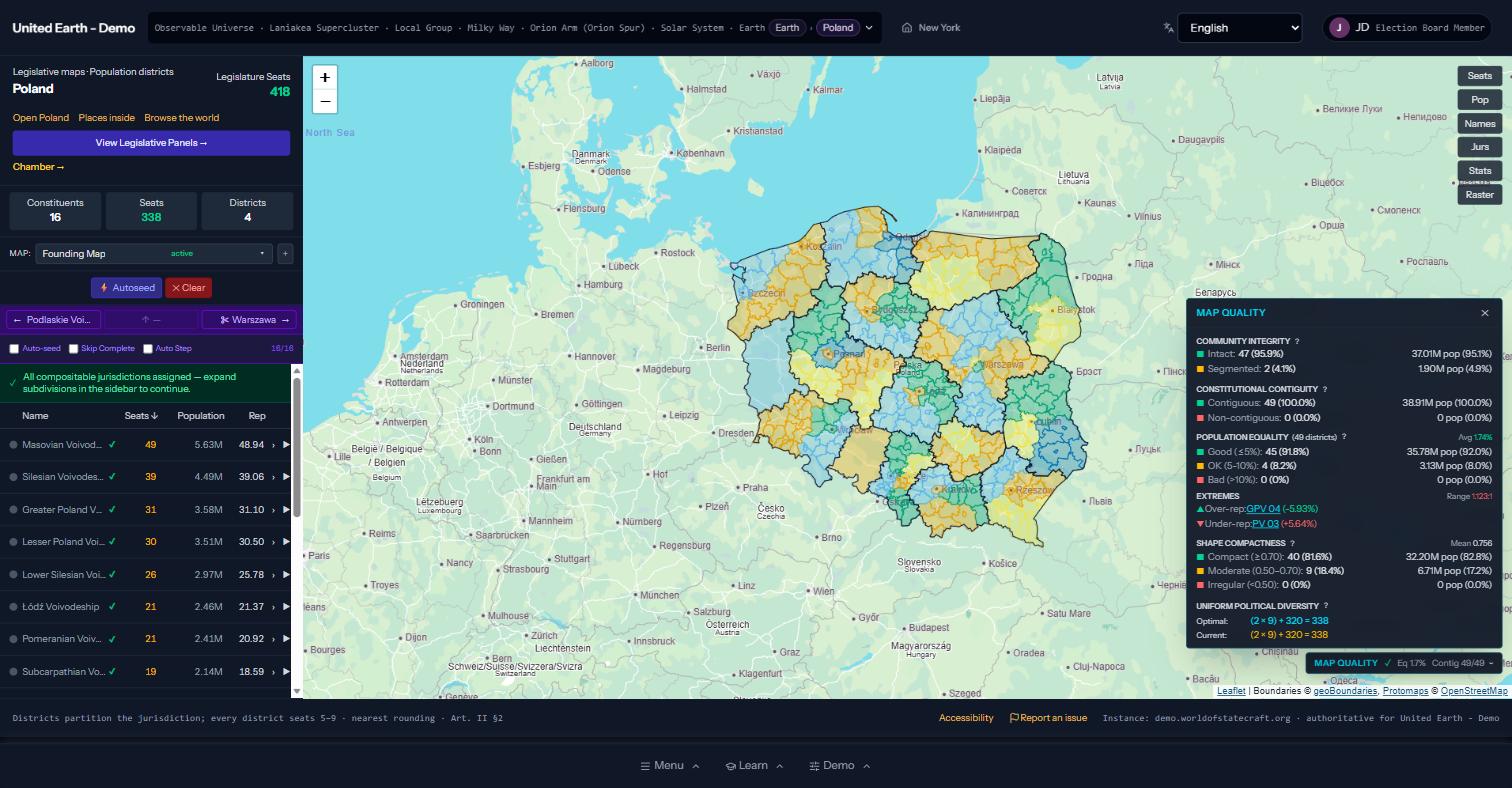
Poland in the live demo, with the Map Quality panel open.
One Chamber for People, One for Places
Proportional Population Maps
Seats follow people. The chamber is sized by population and divided into districts of five to nine seats, with population shares made as exact as the geography allows.
Equal Constituent Maps
Seats follow places. Every member jurisdiction receives the same number of seats whatever its population, so a small member is never simply outvoted. When the members are too many, neighbors are grouped into shared panels, evenly and compactly, and no border is ever cut.
The first-draft maps in the engine are generated automatically. They satisfy the law, and they publish their scores, but they are drafts. An independent election board can accept a draft, redraw it, or replace it, and every version is kept. The standards do not claim a perfect map exists. They make every map's imperfections visible and comparable.
Open the Maps in the Live Demo
A National District Map
Poland, with its districts, seats, and quality panel.
Related Reading
How the Maps Are Drawn
Open boundary and population data, combined into first-draft districts for the whole planet.
Polymorphic Voting
An election that is always open: approvals, public endorsements, then a proportional ranked count.
The Constitutional Engine
One gate for every civic act, a tamper-evident public record, and rules no administrator can bend.
Legislatures in the Template
The constitutional text on independent election boards, proportional voting, and districts.
Proportional Ranked Choice Voting
Why multi-seat districts represent nearly every voter, and how the count works.
Jurisdictions in the Template
Nested jurisdictions, joint powers, and the two kinds of representation.
Get Involved
Find the Flaw in Our Standards
If you study redistricting, electoral geography, or constitutional law, we want your critique. Open a map, read its scorecard, and tell us what the standards miss.